
Quick Facts

Biography
Martin Waldseemüller (Latinized as Martinus Ilacomylus, Ilacomilus or Hylacomylus; 11 September 1470 – 16 March 1520) was a German cartographer.
He and Matthias Ringmann are credited with the first recorded usage of the word America, on the 1507 map Universalis Cosmographia in honour of the Florentine explorer Amerigo Vespucci.
Life
Waldseemüller was born in Wolfenweiler near Freiburg im Breisgau (his mother came from Radolfzell) and he studied at the University of Freiburg.
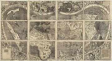
On 25 April 1507, as a member of the Gymnasium Vosagense at Saint Diey (German: Sankt Didel) in the duchy of Lorraine (today Saint-Dié-des-Vosges, France), he produced a globular world map and a large 12-panel world wall map using the information from Columbus and Vespucci's travels (Universalis Cosmographia), both bearing the first use of the name "America". The globular and wall maps were accompanied by a book Cosmographiae Introductio, an introduction to cosmography. The book, first printed in the city of Saint-Dié-des-Vosges, includes in its second part, a translation to Latin of the Quattuor Americi Vespuccij navigationes (Four Voyages of Americo Vespucci), which is apparently a letter written by Amerigo Vespucci, although some historians consider it to have been a forgery written by its supposed recipient in Italy.
In the seventh chapter of the Cosmographiæ Introduction, written by Matthias Ringmann, it is explained why the name America was proposed for the then New World, or the Fourth Part of the World:
Atque in sexto climate Antarcticum versus et pars extrema Africæ nuper reperta. . . . et quarta orbis pars (quam quia Americus invenit Amerigen, quasi Americi terram, sive American nuncupare licet) sitae sunt
Translation:
And in the sixth climate toward the Antarctic, the recently discovered farther part of Africa . . . and a fourth part of the world (which may be called Amerige, as if meaning "Americus' land", or America) are situated
In the ninth chapter of the same book the reasons for the name America are given in more detail:
Nunc vero et hæ partes sunt latius lustratæ et alia quarta pars per Americum Vesputium (ut in sequentibus audietur) inventa est, quam non video cur quis jure vetet ab Americo Inventore sagacis ingenii viro, Amerigen quasi Americi terram sive Americam dicendam; cum et Europa et Asia a mulieribus sua sortita sunt nomina.
Translation:
But now these parts have been more widely explored, and also another fourth part has been discovered by Americus Vesputius (as will be heard in the following), and I do not see why anyone should justifiably forbid it to be called Amerige, as if "Americus' Land", or America, from its discoverer Americus, a man of perceptive character; since both Europa and Asia have received their names from women.
In 1513, Waldseemüller appears to have had second thoughts about the name, probably due to contemporary protests about Vespucci’s role in the discovery and naming of America, or just carefully waiting for the official discovery of the whole northwestern coast of what is now called North America, as separated from East Asia. In his reworking of the Ptolemy atlas, the continent is labelled simply Terra Incognita (unknown land). Despite the revision, 1,000 copies of the world maps had since been distributed, and the original suggestion took hold. While North America was still called Indies in documents for some time, it was eventually called America as well.
The wall map was lost for a long time, but a copy was found in Schloss Wolfegg in southern Germany by Joseph Fischer in 1901. It is still the only copy known to survive, and it was purchased by the United States Library of Congress in May 2003, after an agreement was reached in 2001. Five copies of the globular map survive in the form of "gores" printed maps that were intended to be cut out and pasted onto a wooden globe. Only one of these lies in the Americas today, residing at the James Ford Bell Library, University of Minnesota, three copies are in Germany (Bayerische Staatsbibliothek, LMU Munich, Stadtbibliothek Offenburg), one copy is in London, UK, in private hands.
Waldseemüller died 16 March 1520, ab intestat, then a canon of the collegiate Church of Saint-Dié (located between Nancy, Lorraine and Strasbourg, Alsace in the heart of the Vosges blue mountain range along the Rhine river valley).
